GPSFileDepot.com
 

News:

Welcome to GPSFileDepot!

Main Menu
Menu

Show posts

This section allows you to view all posts made by this member. Note that you can only see posts made in areas you currently have access to.

Show posts Menu

Messages - Boyd

#4006
Mapwel can export .img files with no problem. But you actually have to buy the advanced version: http://www.mapwel.eu/exportmap/hw_export.html

I use this myself and it works great.
#4007
Map Making Support / Re: Hand drawn maps
June 30, 2009, 10:38:35 AM
Yep, that's actually from instructions I posted on another site. Unfortunately you can't run it on the cheaper Tritons. The touchscreen is heavily integrated into Ozi CE and only the 1500 and 2000 have that feature. For starters, you need the touchscreen to enter your registration code.

If you want some of the nice extra features you need to install one of the "unlock" packages on the Triton. It works fine using the instructions above, but you can't do things like suspend the program or change the screen brightness. For more info, visit the Custom Software forum at TritonForum.com.
#4008
It depends on what's in the files, but you might have a look at Mapwel. It should be able to read the shapefiles and load them onto your GPS in Garmin .img format. That does not necessarily mean they will look nice, but it's a start and the software is pretty easy to use: http://www.mapwel.eu/

You can download the trial version and see what you think. The trial version will not export the fully detailed map, but it should display it correctly on your computer screen. Also, have you looked at the Garmin format maps here? http://gpsmapsearch.com/
#4009
GPSr Units / Re: Nuvi 5000
June 24, 2009, 08:01:10 PM
Why would you want to use it outside a car?  ???

Aside from an external battery you would also need the cradle to properly power it. You can power it through the USB connector on the back of the unit, but the maximum brightness will then only be about 50% of what you would have if using the cradle. I gather this is a "feature" and not a bug, since other Nuvi's with cradles behave the same.
#4010
GPSr Units / Re: NUVI 5000 vs 855
June 24, 2009, 07:58:50 PM
No need to call. I have a Nuvi 5000 and it records tracks. In fact, all Nuvi's in Garmin's current lineup record track. Only the older models (which may still be on sale some places) don't track - Nuvi 200, 300 and 600 series.

In fact, the new models are always recording track - you can't disable it. You can only clear the log and choose whether or not to show it on the screen.
#4011
Map Making Support / Re: Hand drawn maps
June 20, 2009, 04:16:29 PM
Have a look at Mapwel, it would do pretty much everything you need (including "rubber sheeting"). You can play with the free version to see if you like it: http://www.mapwel.eu/features.htm

Mapsource is really not the right tool for making this kind of map. But for that matter, a Garmin GPS is really not the right tool for this application either. OziExplorer is a program specifically designed to work with scanned maps (raster images) on the PC, and it has a companion program, OziExplorer CE which runs on Windows CE based gps'es. Raster images can consist of just about anything - scanned maps, satellite photos, USGS quads. I am using it on a Magellan Triton 1500 and it's very impressive. It assumes a certain amount of technical/computer knowledge to get everything working though so it's not for the average consumer. See their site here: http://www.oziexplorer.com/

#4012
More likely than not, maps on this site will have used TIGER road data. I assume you are the same person who asked about this at GPSFileDepot and you are looking for Oregon maps. Since the maps here are free, why not just download one for your area and have a look yourself?

I believe the OpenStreetMap project has also used TIGER data (please correct me if I'm off base here!). You can browse their maps here: http://www.openstreetmap.org/
#4013
GPSr Units / Re: Can I pop the hood on my Nuvi 500?
June 01, 2009, 01:27:35 PM
Assuming the 500 is like other Nuvi's, here's how to save a favorite to include the coordinates. Press Menu > Where To > Coordinates. You will get a screen which shows your current coordinates. There should be a Save button at the bottom of the screen. Tap that and you will save your current position as a waypoint with coordinates.

This is just from memory and I don't have a Nuvi here at the moment. So it might be slightly different but this is the basic concept.

#4014
GPSr Units / Re: Garmin 855
May 21, 2009, 01:23:59 PM
Some of the maps on the site have Macintosh installers. If not, then you would have to install on a PC and run Garmin's mapconvert program.
#4015
GPSr Units / Re: Screen size
May 21, 2009, 01:22:34 PM
The widescreen Nuvi's are really pretty awkward for handheld use. They are just too wide to carry and view comfortably. All of the widescreen Nuvi's have 480x272 pixel screens. The regular ones are 320x240. The Oregon screen is in between at 400x240.

On the larger side, the Nuvi 5000 has a 5" screen at 800x480. But not suitable for handheld use because no battery!
#4016
GPSr Units / Re: Removing map from Nuvi
May 02, 2009, 09:09:43 AM
If you don't know how to use mapsource, how did you install the map?

In almost all cases, maps which a user installs on the Nuvi will be named gmapsupp.img. Connect the Nuvi to your computer and open it up like a disk to view the files. Open the Garmin folder. You should see a file named gmapsupp.img. Just to play it safe, copy that file to a location on your computer in case you want it again later. Then delete the gmapsupp.img file from the Nuvi. DO NOT change any other files on the Nuvi!

If you really want some cheap insurance, before touching anything on the Nuvi, copy the entire contents to your computer. That way you will have a backup which can be restored later if needed. Most Nuvi's have USB 1.0, so it may take quite awhile to copy its contents to your computer (45 minutes?). It will also consume over 2GB of space on your disk, but it could save you a lot of trouble later on if there's a problem.
#4017
After you drag the map into view, you could tap a location and save it as a favorite. Then the next time you want to "visit" Florida you could just pull up the favorite or use the "recently found" function.
#4018
Really, the easiest way would be to just download the update again using the laptop. The link you used the first time should continue to work for awhile. AFAIK, there is no limit to how many computers you can install the maps on, but you can only install them on one GPS.

Otherwise, you could try copying the files directly but you might run into some issues. I believe the location of the files may vary with your version of Mapsource. On my computer they are located in \Garmin\CNNANT2009
#4019
GPSr Units / Re: AERIAL MAPS FOR 60CSX
March 29, 2009, 03:17:25 PM
Quote from: leszekp on March 29, 2009, 03:06:50 PMBut it's worth noting that MapWel has more features than that - it lets you create your own vector-based maps with custom types.
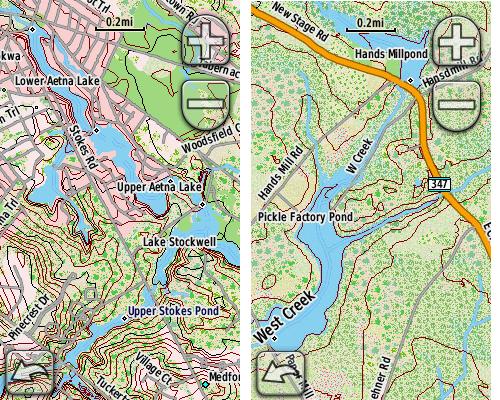
Indeed, I was going to point that out too. I have been using Mapwel advanced for awhile and am really impressed. I have never tried to use the raster conversion features myself. But the custom styles editor is worth the price of admission for me. There is just no practical way that I could have created maps like these using "ASCII art" with cgpsmapper!


The Mapwel compiler is also very impressive. I found it was 3 to 5 times faster than cgpsmapper in my project. It does have some quirks and limitations though. The custom styles are applied individually to each map segment and there doesn't seem to be a way to just drop one .typ file into a whole mapset. I have posted about this on the Mapwel list and the author said he would look into it. I know that one of Oz's issues is that it doesn't play nice with Mapsource. For me, that's not a big deal but I can see why it would be a problem for some people. I wrote about my Mapwel impressions here: http://forums.gpsfiledepot.com/index.php/topic,152.msg1045.html#msg1045

OziExplorer CE is one of those solutions for Windows Mobile and Windows CE. I have used this extensively as well, and it's really cool. Works great on my HP iPAQ 310.
#4020
GPSr Units / Re: AERIAL MAPS FOR 60CSX
March 29, 2009, 01:43:41 PM
The way things currently stand, what I really think you need is a different GPS. The Oregon can now support raster-based maps but nobody has yet figured out how to create our own maps in this new format. If you want aerials here and now, take a look at the DeLorme PN-40. I haven't used one myself, but it has a very loyal user base. For a relatively inexpensive yearly subscription you can download all the imagery you want.

The 60csx just isn't going to be a good platform if you want raster imagery. It only supports vector based maps and limited kinds of filled polygons. Couple that with a relatively slow processor, a low resolution screen with only 8 bit color depth, and you are going to be fighting the hardware even when using MOAGU.