GPSFileDepot.com
 

News:

Welcome to GPSFileDepot!

Main Menu
Menu

Show posts

This section allows you to view all posts made by this member. Note that you can only see posts made in areas you currently have access to.

Show posts Menu

Topics - Boyd

#21
Map Making Support / Making maps for Lowrance
April 09, 2013, 05:51:15 AM
Recently I've gotten curious about other vector map formats, and realized that I knew next to nothing about Lowrance. Digging around on their site, they have something very cool - free emulators that you can download for many of their devices. These are like a "virtual gps" that works just like the real thing although they can't be used for navigation. What  a great idea - I wish Garmin would offer the same thing.

Anyway, I noticed that Globalmapper is able to export vector data in Lowrance's .lcm format so I tried a few tests. Didn't go well at first; when I used the 64 bit version of GM 12 I got an error that some kind of .dll was missing when I tried to export. I had the 32 bit version handy on my Windows tablet, so I made a really simple "map"with only one line object and tried exporting. It seemed to hang for awhile, and when I looked it had created over 1100 files on my desktop where I wanted to save the map! Had to kill GM and delete all the files.

Still not ready to give up, I dug around and realized I also had the 32 bit version of GM on my desktop machine. This time it worked like a charm and I was able to install a simple map that contained major roads in my area. It wasn't pretty, but it worked on the emulator. So I tried exporting a full 24k quad from my NJ topo and that also worked fine.

Obviously it would take some work to clean this up and make it look good on Lowrance, but really the process was very straightforward. The cool thing is that you can export directly from Globalmapper and it is really fast - no need for cgpsmapper or other software.

Anyone else ever play with this? Does anyone actually have one of these devices? The hardware is interesting - 5" screen at 480x480 pixels. They are rather expensive, and I gather they dropped support for topo maps a couple years ago which made a lot of people mad. They have just released some new topo products though - http://www.gpscity.com/lowrance-topo-insight-pro-2013-east-microsd-card.html

Anyway, I suspect there are a bunch of people out there who would love free maps for their Lowrance devices. If you want to play around with this, the emulators are available here: http://www.lowrance.com/en-US/Support/Product-Emulators/ I have been playing with the Elite-5 Emulator.

To install a map, first find the emulator program folder - C:\Program Files (x86)\Navico\Elite-5 on my Vista system. Create a new folder named Maps0, then copy the .lcm file you exported from Globalmapper there. I suggest that you create a temporary folder somewhere and use it when you export your globalmapper file.... just in case it decides to create thousands of files like it did with my earlier test.  :)

#22
GPSr Units / GLONASS
April 02, 2013, 09:40:06 AM
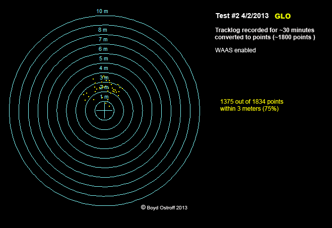
I got a Garmin GLO last week and have been putting it through its paces. If you aren't familiar with the GLO, it's a very small GLONASS-enabled bluetooth GPS receiver that sends position data to applications running on a laptop, tablet or phone.


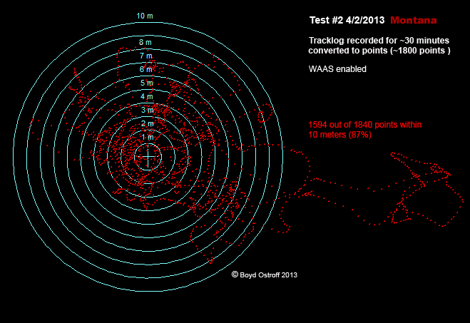
While this specific device may not have broad appeal, the GLONASS performance is remarkable. Here's a test I did this morning side by side with my 60csx and Montana sitting stationary at a known location. You can see that the GLO is a completely different kind of device. It appears to have created less points than the other devices, but in fact they're all there, just stacked on top of each other. I don't think I will buy another handheld unless it also has GLONASS.  :)


#23
I have always wanted to do this so will be very interested to have a look at TypWiz 4 when it is introduced this spring.  :D

http://pinns.co.uk/osm/typwiz3.html

#24
See the following post from one of the Basecamp developers: https://forums.garmin.com/showthread.php?34189-Wish-list-for-Basecamp&p=164244#post164244

Quote from: FALAGARIn the future, you will hopefully be able to display more than 1 map at the same time which should solve this issue. (This future is probably still a distance away, I don't think this will happen in 4.2.)
#25
Generally speaking I like the National Map better than the old seamless server. But I have found some bugs/anomalies. I have been downloading NED 1/9 arc second data using 24k reference polygons. Some of the downloads result in corrupt zip files ~800kb that can't be opened (a proper download would be in the 50-60MB range).

I don't think these are failed downloads, they are just quads for which no data is available. But the data selection dialog claims that 2011 NED 1/9 is available. These are areas where no data was available a couple years ago when I started collecting the NED 1/9, so again it isn't surprising. But you have to go through the whole process of ordering and downloading only to get the little garbage file.

Some of the 2011 NED 1/9 is actually available for download, but it's a crapshoot and the only way to find out is the make the download attempt. No big deal, just a small annoyance. I wonder if the 2011 data is actually available but they just haven't put it all online yet?

Anyone else see these kind of glitches with the National Map?
#26
GPSr Units / New garmin models coming at CES next week
January 05, 2013, 07:36:31 PM
See: http://forums.gpsreview.net/viewtopic.php?p=182259#182259

Some interesting new features and hardware in the Nuvi series, but nothing that gets me very excited. If the specs are correct, it appears they are introducing a 7" device with a resolution of only 480x272.  :o

Now let's see what they might have in the handheld department. There have been rumors of new Oregon and Edge models but I haven't seen any specifics.
#27
General Discussion / Mapping out the new year
January 05, 2013, 12:07:55 PM
What kinds of projects are other mapmakers planning for the year ahead?

For starters, I am learning my way around the Google Maps API and have an alpha version of my LIDAR based map of the New Jersey Pine Barrens running in a browser. Sitting here right now with a "Teach yourself Javascript" book next to the computer.  ;D

Kind of slow getting started, but it has only taken me about 3 days to get a barebones site up and running. Lots of files involved with this... using my settings, about 4,000 map tiles are required for each USGS 24k quad. I might transition this to some other kind of software since I'm not using any of the Google-specific features or maps, just their interface for displaying my own map data.


Also have an alpha version of another project which uses the same high-res LIDAR data in .kmz files as a Garmin Custom Map. I have a companion transparent Garmin Vector Map (.img file) containing roads and POI's that can be overlaid on the .kmz. Each USGS quad requires 16 .jpg files so that limits most Garmin handhelds to a total of 6 quads at a time (96 tiles) although the Montana can handle 31 quads.


Not sure what else I might tackle this year. I'm interested in a lot of things, but as you know, this stuff takes a lot of time! Happy New Year to all!  :)
#28
There seems to be a bug in the current version of Basecamp that can cause the basemap to be displayed at the same time as other maps. In the course of discussing this, one of the Basecamp developers says that adding support for transparent overlays (such as MyTrails) is actually on their "to do list".  :)

See: https://forums.garmin.com/showthread.php?32540-Bug-BaseCamp-shows-roads-twice&p=155857#post155857

#29
Just noticed this on Garmin's site.

https://forums.garmin.com/showthread.php?30950-Garmin-Training-Center-is-no-longer-maintained-or-supported-by-Garmin

QuoteGarmin Training Center is no longer maintained or supported by Garmin

Please note that Garmin has decided to discontinue development of Garmin Training Center for Windows and Garmin Training Center for Macintosh. Garmin recommends that users of Garmin Training Center transfer their data to Garmin Connect. This forum will remain open for users that decide to continue to use Garmin Training Center and collaborate with other users but Garmin will no longer provide support in this forum. Garmin apologizes for any inconvenience this may cause for our customers.

I also think the Mapsource install tutorial is no longer correct: http://www.gpsfiledepot.com/tutorials/how-to-install-mapsource-if-it-didnt-come-with-your-gps/

QuoteIf you have limited bandwidth you can download Garmin Training Center as step one and then MapSource.

For quite some time users have reported that this no longer works, due to changes in Training Center. The "trick" relied on the fact that Training Center included a basemap, but I believe that was removed from the package awhile ago.
#30
Enter coupon code FALL20 at checkout when you buy maps or accessories at https://buy.garmin.com/shop/ (map updates excluded). This is a cheap way to get a copy of City Navigator for your handheld - the Lower 49 version would only be $48 with the discount: https://buy.garmin.com/shop/shop.do?cID=253&pID=28765
#31
Map Making Support / Bulk USGS Data
September 12, 2012, 06:04:07 PM
Stumbled across this today while looking for some data: http://seamless.usgs.gov/bulk.php

Unless I am missing something here, it sounds like you can send USGS a hard drive, receive it back a month or two later full of data, and the only charge is the shipping. If so, that's pretty cool.  8)

Quite a list of available stuff too - like the full DRG dataset (238GB) or the full 1/9 arc second (LIDAR) dataset (2.03 terrabytes) or ful DOQ dataset (16.9 terrabytes).

Anybody ever use this service?
#32
See: http://garmin.blogs.com/softwareupdates/2012/08/garmin-basestation.html

Basecamp will now show your position... but you need to have an Astro, Alpha or Rino gps to connect. Now if they would only allow you to connect other types of USB devices, this would be the answer to what many people have wanted...

QuoteGarmin Basestation

The latest version of Garmin BaseCamp introduces a handy new feature for your tracking handhelds: Basestation. With Basestation, every update received from other devices by your tracking handheld is sent to BaseCamp, allowing you to track yourself, your dogs, and your contacts on your computer. This can free your hands and allow you to see more of the map on a bigger screen. You might find Basestation ideal for a variety of situations, including tracking dogs at hunting competitions or coordinating search and rescue or fire fighting operations.

Supported Handhelds

Astro 320
Alpha 100
Rino 600 series

To ensure Basestation compatibility on these devices, make sure you have the latest software from WebUpdater. BaseCamp must be at version 4.0 or later.


#33
Garmin just released new firmware for the Nuvi 3700 series today that has a rather radical change: http://www8.garmin.com/support/download_details.jsp?id=5063

Changes made from version 4.80 to 4.90:

Made a change so that Topo/Recreational and City Navigator Maps cannot be enabled at the same time.

I wonder if we will see this "feature" appear on other devices now? I am really puzzled... is it a response to people who complain they can't see their topo map because City Navigator is hiding it? Or has Garmin decided they don't want anyone "riding their coat tails" and using overlays?

I am not sure how they determine if another map is a "Topo/Recreational" one. And I don't intend to install this on my 3790 to find out either.

Wow.
#34
Some very nice pricing - I think this is the lowest price ever on the Montana

$152 - eTrex 20
$231 - eTrex 30
$240 - Oregon 450
$320 - GPSMap 62s
$400 - Montana 600

This is just a partial list, see the rest here: http://www.ems.com/family/index.jsp?categoryId=3716800&emssrcid=AFF%3AGAN_k172286
#35
I haven't tried this yet myself - has anyone else? http://www8.garmin.com/support/agree.jsp?id=3291

See the discussion here on Garmin's support forum: https://forums.garmin.com/showthread.php?t=27145

#36
OK - don't panic, everything is probably fine, but if you're on a Mac it's worth checking this out. I posted about it here, but most people probably won't make the connection: http://forums.gpsfiledepot.com/index.php?topic=2771.msg16548#new

When GPSFileDepot was recently hacked, it appeared pretty innocuous and only resulted in users being redirected to some harmless looking sites. Now I have learned that these sites are included in the ones which have been spreading a Mac virus/trojan that's been getting a lot of publicity: http://news.yahoo.com/more-600-000-macs-infected-flashback-malware-report-091608469.html

To check if your Mac is infected, open the Terminal program (found in the Utilities folder inside the Applications folder). Paste the following command into terminal

defaults read /Applications/Safari.app/Contents/Info LSEnvironment

Hit the return key and now paste this command into Terminal

defaults read ~/.MacOSX/environment DYLD_INSERT_LIBRARIES

If you get a response saying that the domain/pair does not exist for each of these, you are not infected. The strange thing is that if you have Microsoft Office 2008, Office 2011 or Skype on your Mac, evidently the virus won't get installed. Maybe that's why I'm clean?

Apple has issued a software update to close this vulnerability. If I understand correctly, it should also remove the virus if present. The same virus also affects Windows machines and has been around for awhile, so hopefully you will be OK there if your antivirus software is up to date.
#37
Map Making Support / Online .typ editor down?
March 09, 2012, 05:19:32 AM
For the past day I've been trying to access the online .typ editor at http://ati.land.cz/gps/typdecomp/editor.cgi and all I get is

QuoteNot Found
_____________________________________________________________
The requested URL /gps/typdecomp/editor.cgi was not found on this server.
Apache/2.2 Server at ati.land.cz Port 80

I hope this is just temporary. I have tried all the other ways to edit .typ files (which I do extensively) and this still remains the best.

The only viable alternative is typWiz, but it is still buggy: http://pinns.co.uk/osm/ostyp.html

I spent awhile using it on my last map and ended up going back to the online editor after my .typ file became corrupted when changing draw order. I also wasn't able to get the extended font support to work correctly in some cases. It's a very nice program though, so I guess I'll have to learn to live with the problems if the online editor is really gone.  :(
#38
General Discussion / End of the line for Lightsquared
February 15, 2012, 07:05:06 AM
Really, it's ridiculous that this has gone on for so long IMO...

http://gpstracklog.com/2012/02/fcc-kills-lightsquared.html#more-14752

QuoteFCC kills LightSquared

February 15, 2012 by Rich Owings   

The National Telecommunications and Information Administration (NTIA) wrote the FCC yesterday (PDF) saying they had concluded "that LightSquared's proposed mobile broadband network will impact GPS services and that there is no practical way to mitigate the potential interference at this time." Shortly thereafter, the FCC announced that they would "(1) vacate the Conditional Waiver Order, and (2) suspend indefinitely LightSquared's Ancillary Terrestrial Component authority to an extent consistent with the NTIA letter."
#39
Map Making Support / Experiments with LIDAR
December 27, 2011, 09:15:55 PM
We have pretty extensive coverage in Southern New Jersey with USGS NED 1/9 arc second LIDAR DEM, so I'm trying to find a way to use this in a map. It's especially nice around here where everything is so flat because it reveals a lot of surface detail in the forest.

It would be very easy to make a garmin "custom map" (.kmz raster image) from this data, but it's pretty limiting both in size and in the number of devices that can use it. So my thought was to vectorize it using Globalmapper's function to create polygons based on RGB values.

I have all the data, so for starters I cropped it to the outline of the map I want to make, then exported it as gridded 8 bit grayscale TIFF's that are ~500x500 pixels. Globalmapper converts these into anywhere between 50,000 to 60,000 polygons when using a match distance of 16. Smaller values for match distance create way too many polygons.

Here's a comparison of the original TIFF to the vector image. Globalmapper really does a great job - it's hard to tell them apart until you zoom way in.


Next I export a shapefile and use Filemaker Pro to do some processing of the .dbf, parsing the RGB values and mapping them to MP_TYPES in a custom .typ file. I decided to go this route instead of using a program like MOAGU or Mapwel because it gives me full control over everything.

I then import the modified shapefile back into Globalmapper, combine with other vector features like roads, then export an .mp file to compile with cgpsmapper. My current prototype breaks a USGS 24k quad into 8x8=64 tiles, each of which is ~1MB. So far so good. Here's what it looks like in Globalmapper


And the compiled map in Mapsource looks surprisingly good - bet ya didn't think Mapsource could do this!  ;)


But then the fun begins... there are two problems on the GPS. First, it practically brings the unit to its knees due to all the little polygons (I tried on a Nuvi 205 and Montana 600). But worse, the GPS doesn't seem to render the image with as much precision as Mapsource, even with detail set to max. Basically, it's a mess. Kind of an interesting abstract art image, but nothing like the original.


So I'm going to need to re-think this and do more experimentation.  :)

Anyway, it's an interesting although time consuming and sometimes frustrating project that I wanted to share. I have also recently refined my technique for processing the Landsat NLCD 2006 landcover data in a similar fashion and that is working out really well - but that source imagery is about 10 meters pixel. I'll post some details about this in another thread soon.

Hope everyone is enjoying the holidays - here's wishing a happy New Year to all! :)
#40
Site Support / Broken link in Mapmaking tutorial #1
December 20, 2011, 05:44:46 PM
Just noticed this, for what it's worth...

See: http://www.gpsfiledepot.com/tutorials/how-to-create-garmin-topo-maps---part-1---setup/

QuoteI will not go into a lot of detail on how to use this excel spreadsheet at this time.  The descriptions are available in the article and as I use each feature it will be metioned.

The link to the article doesn't work. It takes you to the index page for the tutorials - http://www.gpsfiledepot.com/articles/100k-quad-lists-and-dem-links-for-each-state/