
- Welcome to GPSFileDepot Forums.
Recent posts
#1
General Discussion / Re: Another free OSM topo map ...
Last post by Boyd - October 04, 2026, 02:05:01 PMI no longer use Garmin devices or maps, but that's a nice website - beautiful photo - and nicely organized. It's great that you are offering all of this for free with no ads or registration. Good job!
#2
General Discussion / Another free OSM topo map proj...
Last post by LukasM - September 29, 2026, 11:26:27 PMHi all,
I recently discovered this forum and its great maps. I live in Switzerland, and as a free-time project I've been making maps for Garmin devices for a few years now, so I thought I'd share them with you too.
The project is called LuckyMaps. They're free OpenStreetMap topo maps for Garmin units. It's built on, and expands on, the great European project Freizeitkarte.
The maps cover almost the whole world, including the entire US, split into states and larger regions (Midwest, Pacific, etc.). It's purely non-commercial: no ads, no donations, no subscription.
The maps offer routing for car, bike and foot, plus POIs, with a clean style that works on both large and small screens, in nature as well as in the city. Contour lines are a separate download, so you can add them only where you need them. The maps are usually updated twice a year.
I personally use the maps regularly on the eTrex Touch (2025), fēnix 7X Pro and GPSMAP 276cx (for driving). I've also tested them on the Montana 600, Oregon 400/600/750t and GPSMAP 64/65.
Hope they're useful to someone. Any feedback is very welcome.
Cheers,
Lukas
P.S. A great program for planning on a computer is QMapShack (https://github.com/Maproom/qmapshack). Garmin no longer develops BaseCamp, so I recommend it as an alternative. It's free, open source, and runs on Windows, Mac and Linux. It opens Garmin .img maps (LuckyMaps included) directly, so you can plan tracks and routes on the same map you'll see on your device and then send them to the unit, since it supports device sync.
You cannot view this attachment.
You cannot view this attachment.
You cannot view this attachment.
You cannot view this attachment.
You cannot view this attachment.
You cannot view this attachment.
I recently discovered this forum and its great maps. I live in Switzerland, and as a free-time project I've been making maps for Garmin devices for a few years now, so I thought I'd share them with you too.
The project is called LuckyMaps. They're free OpenStreetMap topo maps for Garmin units. It's built on, and expands on, the great European project Freizeitkarte.
The maps cover almost the whole world, including the entire US, split into states and larger regions (Midwest, Pacific, etc.). It's purely non-commercial: no ads, no donations, no subscription.
The maps offer routing for car, bike and foot, plus POIs, with a clean style that works on both large and small screens, in nature as well as in the city. Contour lines are a separate download, so you can add them only where you need them. The maps are usually updated twice a year.
I personally use the maps regularly on the eTrex Touch (2025), fēnix 7X Pro and GPSMAP 276cx (for driving). I've also tested them on the Montana 600, Oregon 400/600/750t and GPSMAP 64/65.
Hope they're useful to someone. Any feedback is very welcome.
Cheers,
Lukas
P.S. A great program for planning on a computer is QMapShack (https://github.com/Maproom/qmapshack). Garmin no longer develops BaseCamp, so I recommend it as an alternative. It's free, open source, and runs on Windows, Mac and Linux. It opens Garmin .img maps (LuckyMaps included) directly, so you can plan tracks and routes on the same map you'll see on your device and then send them to the unit, since it supports device sync.
You cannot view this attachment.
You cannot view this attachment.
You cannot view this attachment.
You cannot view this attachment.
You cannot view this attachment.
You cannot view this attachment.
#3
General Discussion / Re: This is the number one sit...
Last post by Boyd - September 03, 2026, 04:10:36 AMThanks, I do what I can! But I might look at things just a little differently. *who* is downloading all those maps? Are they really human beings that want maps to use on their Garmin GPS units? Or some kind of bots or people who think they can somehow make a buck from what is freely offered? Honestly, I have no idea and truly want to believe your analysis.
But I see the side that you don't here in the forums, and it's pretty ugly. Will only say, most people who (try to) post here are not looking for help with maps.
And on my own site, I am constantly looking at the server logs. It can be hard to be idealistic in the face of that reality. Yet, I keep trying and continue to make my own maps and write my own code. And continue to try keeping the bad guys away from the forums, but I have no visibility into the map downloads or the server itself here.
Keep making your maps and keep that positive attitude - we need more people like you!
But I see the side that you don't here in the forums, and it's pretty ugly. Will only say, most people who (try to) post here are not looking for help with maps.
And on my own site, I am constantly looking at the server logs. It can be hard to be idealistic in the face of that reality. Yet, I keep trying and continue to make my own maps and write my own code. And continue to try keeping the bad guys away from the forums, but I have no visibility into the map downloads or the server itself here.
Keep making your maps and keep that positive attitude - we need more people like you!
#4
General Discussion / This is the number one site fo...
Last post by AdvOSM - September 02, 2026, 10:59:19 PMAccording the website host, the largest source of visitors (from 116 countries so far) to the AdvOSM Adventure Road Maps website is a click on a GPS File Depot link!
34% GPS File Depot
30% OSM Garmin Wiki
24% Direct
8% Facebook
4% Google and Other
Every one of the 22 maps is downloaded nearly every day, about 900 a week at the moment, with this regional frequency:
30% North America
22% Europe
15% Africa
9% Other Western Hemisphere
9% Central Asia
8% East Asia
8% Australia and Oceania
So many thanks, Boyd, for putting up with the spammers and keeping the GPS File Depot lights turned on.
34% GPS File Depot
30% OSM Garmin Wiki
24% Direct
8% Facebook
4% Google and Other
Every one of the 22 maps is downloaded nearly every day, about 900 a week at the moment, with this regional frequency:
30% North America
22% Europe
15% Africa
9% Other Western Hemisphere
9% Central Asia
8% East Asia
8% Australia and Oceania
So many thanks, Boyd, for putting up with the spammers and keeping the GPS File Depot lights turned on.
#5
General Discussion / Re: Florida Topo MAP in Garmin...
Last post by Boyd - August 29, 2026, 05:07:12 AMI have zero experience with this device (or any marine GPS units, for that matter). But a quick google search says Garmin has specifically designed this device NOT to work with third party maps and it will just ignore any .img files you try to load, pointing to this section of the owners manual:
https://www8.garmin.com/manuals/webhelp/echomapplus/EN-US/GUID-51071E50-B9F6-4CE7-8AC6-03576D9D7918.html
"To help you have a safe and enjoyable time on the water, Garmin® devices only support official maps produced by Garmin or an approved third party producer."
Maybe somebody has hacked this? Let's see if you get any other responses (I wouldn't count on it though ).
).
https://www8.garmin.com/manuals/webhelp/echomapplus/EN-US/GUID-51071E50-B9F6-4CE7-8AC6-03576D9D7918.html
"To help you have a safe and enjoyable time on the water, Garmin® devices only support official maps produced by Garmin or an approved third party producer."
Maybe somebody has hacked this? Let's see if you get any other responses (I wouldn't count on it though
). #6
General Discussion / Florida Topo MAP in Garmin Cha...
Last post by STUFF2C - August 29, 2026, 03:32:22 AMGood morning everyone, I'm brand new here in the forums, but I've been using the Florida Topo map for years in my Garmin handheld.
Recently, I purchased an echo map +44 CV and I'm trying to figure out a way to make it work in this unit.
Any suggestions? Thanks in advance.
Recently, I purchased an echo map +44 CV and I'm trying to figure out a way to make it work in this unit.
Any suggestions? Thanks in advance.
#7
Site Support / Re: Incomplete Country List
Last post by AdvOSM - July 18, 2026, 12:46:28 AMA little off topic, but rather than start another thread, I'll mention that I tried to make a donation from Singapore, and PayPal said "Donations to this recipient aren't supported in this country." I'm in Thailand at the moment, and tried from here, too, same message: "Donations to this recipient aren't supported in this country." I'm trying to help, but it seems that nothing related to Garmin maps is ever easy ... Another country list deficiency, but this time at PayPal!
#8
Site Support / Re: Incomplete Country List
Last post by Boyd - June 30, 2026, 06:22:03 AMThanks! Lots of new things are coming to boydsmaps, but such a big re-write that it will take until 2027 to finish. I'm trying to completely re-imagine what a map website should be.
The new version will actually be a unix-like operating system (written "from scratch") that runs right on the webpage, a completely private virtual machine with it's own private filesystem and graphical user interface. On a computer, it has multiple map and data windows that "talk" to each other. Still playing with completely new ideas for the mobile interface.
But it has multiple "tiers", starting with a dead-simple one for people who just want to click on links and look at maps. The most advanced tier has multiple unix-like terminal windows, with standard unix commands plus a suite of new commands for working with maps. Virtually everything is customizable. Lots of fun - tons more work to do - but it's already running on my development machine.
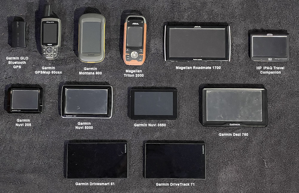
Regarding Garmin, I've spent literally thousands on their devices, starting with a StreetPilot 2620 in 2004 (IIRC) - here are the ones I still have. Gave many other to friends over the years.
You can look way back at my posts on this forum and see how excited I used to be about Garmin. But I just got frustrated, Garmin doesn't want you to make your own maps. For Garmin, a map is nothing but a "profit center". And they simply can't handle the data-rich maps I make (which are no problem on a phone).
But keep making those free maps! It's great there are still people doing that. Lots of people still have old Garmin devices, even if they can't afford new ones ($450 for an eTrex???). I tried firing up my Montana 600 the other day. After it warmed up I got "phantom clicks", opening random menus non-stop like it was posessed, LOL. I believe this is the classic sign of a failing resistive touch screen.
The new version will actually be a unix-like operating system (written "from scratch") that runs right on the webpage, a completely private virtual machine with it's own private filesystem and graphical user interface. On a computer, it has multiple map and data windows that "talk" to each other. Still playing with completely new ideas for the mobile interface.
But it has multiple "tiers", starting with a dead-simple one for people who just want to click on links and look at maps. The most advanced tier has multiple unix-like terminal windows, with standard unix commands plus a suite of new commands for working with maps. Virtually everything is customizable. Lots of fun - tons more work to do - but it's already running on my development machine.
Regarding Garmin, I've spent literally thousands on their devices, starting with a StreetPilot 2620 in 2004 (IIRC) - here are the ones I still have. Gave many other to friends over the years.
You can look way back at my posts on this forum and see how excited I used to be about Garmin. But I just got frustrated, Garmin doesn't want you to make your own maps. For Garmin, a map is nothing but a "profit center". And they simply can't handle the data-rich maps I make (which are no problem on a phone).
But keep making those free maps! It's great there are still people doing that. Lots of people still have old Garmin devices, even if they can't afford new ones ($450 for an eTrex???). I tried firing up my Montana 600 the other day. After it warmed up I got "phantom clicks", opening random menus non-stop like it was posessed, LOL.
I believe this is the classic sign of a failing resistive touch screen. #9
Site Support / Re: Incomplete Country List
Last post by AdvOSM - June 30, 2026, 12:09:30 AMTo get around the missing countries problem I will state the names of the countries at the start of each the map description. That way, if someone types say, Malaysia, in the search bar, he will find it immediately. That works fine.
This site is still important, nothing else like it.
I think Garmin blew it by not embracing OSM (e.g. not supporting third-party Unicode maps, but instead blocking them in Zumos and all models after 2016) and not publishing the IMG file specifications. Of course cheap cellphones and wireless data will eventually do to Garmins what cellphones did to cameras, at least in civilized places, but they could have kept sales up a lot longer if they partnered with OSM instead of trying to cripple it. My 2008 Oregon 450 runs maps that a new Garmin won't run because Garmin cranked up the copy protection. That's sad.
I had a look at boydsmaps. Very Impressive.
This site is still important, nothing else like it.
I think Garmin blew it by not embracing OSM (e.g. not supporting third-party Unicode maps, but instead blocking them in Zumos and all models after 2016) and not publishing the IMG file specifications. Of course cheap cellphones and wireless data will eventually do to Garmins what cellphones did to cameras, at least in civilized places, but they could have kept sales up a lot longer if they partnered with OSM instead of trying to cripple it. My 2008 Oregon 450 runs maps that a new Garmin won't run because Garmin cranked up the copy protection. That's sad.
I had a look at boydsmaps. Very Impressive.
#10
Site Support / Re: Incomplete Country List
Last post by Boyd - June 29, 2026, 08:49:58 AMThanks, and I'm sure he will appreciate it. Just "don't hold your breath" because that might take years. It's sad, having been around for so many years and remembering the great discussions we had about making Garmin maps. But those days are gone. And I mean *long* gone. What you see in the forums is very different from my view, where there are endless spam posts (some of which are very offensive) practically every day that I delete. Then they're back again the next morning, and having moderated at a number of sites, including one of the biggest forums on the net, I can say that this forum software is - hands down - the absolute worst when it comes to moderator tools.
But "it is what it is".... right? I try not to think about it, just ban the bad guys and move on. It's nice to see an actual post about maps though. It's no exaggeration to say I could count those annually on my fingers without even taking off my shoes.
I am in my "post Garmin" phase and loving it, with my web app at boydsmaps, featuring 3tb of free maps, no ads and no registration. I went in that direction because Garmin just doesn't come close to supporting the kind of maps I want to make and I don't want to limit myself to the kind of person who is willing to jump through all the hoops to install maps on a Garmin device. My own maps are only a click away!
Garmin is the past. I am interested in today... and tomorrow. That future does not belong to Garmin and their expensive proprietary devices or closed map format.
But - don't get me wrong - good on you for making maps and posting them here! I was deep into that at one time and it's an experience that I will never regret!
(JMHO, of course and certainly not "site policy" )
)
But "it is what it is".... right? I try not to think about it, just ban the bad guys and move on. It's nice to see an actual post about maps though. It's no exaggeration to say I could count those annually on my fingers without even taking off my shoes.
I am in my "post Garmin" phase and loving it, with my web app at boydsmaps, featuring 3tb of free maps, no ads and no registration. I went in that direction because Garmin just doesn't come close to supporting the kind of maps I want to make and I don't want to limit myself to the kind of person who is willing to jump through all the hoops to install maps on a Garmin device. My own maps are only a click away!
Garmin is the past. I am interested in today... and tomorrow. That future does not belong to Garmin and their expensive proprietary devices or closed map format.
But - don't get me wrong - good on you for making maps and posting them here! I was deep into that at one time and it's an experience that I will never regret!
(JMHO, of course and certainly not "site policy"
) Support GPSFileDepot
 Contact Us
 Subscribe to RSS Feed
 Share on FaceBook
© 2007 - 2022 GPSFileDepot.com
A Division of OzTheory
Privacy Policy | Usage Agreement