GPSFileDepot.com
 

News:

Welcome to GPSFileDepot!

Main Menu
Menu

Show posts

This section allows you to view all posts made by this member. Note that you can only see posts made in areas you currently have access to.

Show posts Menu

Messages - eaparks

#1
How to stop Google / Google Earth Pro from automatically updating in Windows 7.  I used Method 1 and then changed updates to "Manual" and downloaded and reinstalled a working version of Google Earth Pro, version 7.3.2.5776 (32 bit).

If you update or install anything new from Google you will need to do this all over again.  I was finding that Google would automatically update in about 7-8 minutes if I didn't get the googleupdate.exe file removed in time.

Remove GoogleUpdate.exe
https://www.pntbrother.com/remove-googleupdate-exe-google-auto-update-on-windows-7-service-registry/

REMOVE GOOGLEUPDATE.EXE (GOOGLE AUTO UPDATE) ON WINDOWS 7 (SERVICE & REGISTRY)


01 METHOD – DESABLE GOOGLEUPDATE.EXE THROUGH CONTROL PANEL
Step 01. Go to Windows Start Menu > Run
Step 02. Type services.msc and click OK
Step 03. Find and Double Click on Google Update Service.
Step 04. Under the General tab, Change the Startup Type setting to Disabled.


Step 05. Now, Go to Control Panel > Administrative Tools > Task Scheduler
Step 06. Find the Scheduler that has "Google Update" > Right Click on it and Disable or Delete it.
Step 07. Reboot your computer.

02 METHOD – DISABLE GOOGLEUPDATE.EXE THROUGH REGISTRY
Step 01. Go to Windows Start Menu > Type regedit in the search field.
Step 02. Navigate to HKEY_LOCAL_MACHINE/SOFTWARE/POLICIES/GOOGLE/UPDATE.
Step 03. Double Click the AutoUpdateCheckPeriodMinutes value in the right pane.
Step 04. Change the Value data to 0.
Step 05. Reboot your computer.
#2
You can in Windows 7, I did.  You have to go into the registry and delete a file and change to manual updates.  Took me a while to get it figured out, but at least it allows me to continue to use Google Earth Pro, which I use all the time.  When I open Google Earth Pro it now tells me there is a new version and asks if I want to update, and of course I say no.

I did a lot of research on the web to see what had to be done to do it and found some old but useful information.  I can go back and look for it if you would like?
#3
I am still using Windows 7 Pro with Mapsource and Google Earth Pro and the only way I found to view Google Earth Pro through Mapsource was to disable the automatic updates with Google and go back to a previous version of Google Earth Pro that does work.
#4
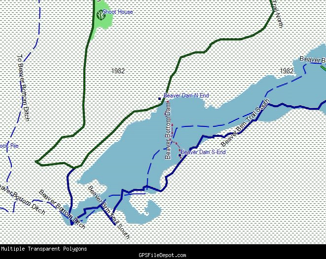
The screenshot I attached is just a small area of the map that I thought showed the type of things you were inquiring about. The water is part of my map, all of this map is mine with no base map.  I have used this/my custom transparent map on my Garmin GPS with Garmin's City Navigator or Garmin's Topo Map set to display at the same time and everything does display properly.
#5
Quote from: fo0bar on May 14, 2019, 12:05:54 AM
I ask because one of my maps is "permitted areas", and another one is "nonpermitted areas". Some of them overlap and I want to ensure the "nonpermitted areas" are always drawn on top of any "permitted areas" - but I need to keep them in separate maps.

Yes, you can do what your asking about above.  You might want to make the permitted areas and non-permitted areas appear as custom colored polygons and you can adjust the draw priority level to have which ever one you want to appear on top.  Maybe one be a colored "x" pattern and the other a colored "-" pattern.  Or just have them as a light solid color.  The example below is 4 custom polygons all with different draw levels with the blue polygon (water on top of the other 2 polygons.  It will take some trial and error to get it just like you want it.


#6
Save the .KML Google Map files; use GPSBabel and batch convert the .kml files to a .gpx file; Add the newly created .gpx file into GPSMapEdit and save as an .mp (polish) file.

As far as the polygons your wanting to create, you are probably already familiar with it, but in case your not.  Create a track/path in Google Earth around what your wanting to be a polygon , save as a .kml file, treat the track/.kml file just like any other file up to the point you add it to GPSMapEdit then "convert to" a polygon instead of a polyline.

Instructions are here on GpsFileDepot for GPSMapEdit if your not familiar with it.  Look in the instructions for Creating Maps.  GPSBabel is pretty well self explanatory.

There are other ways to accomplish the same thing by first converting to a .gpx file but the above way is the way I continue to do it from many years ago, was about the only way to do it 10 years ago.
#7
Map Making Support / Re: Adding a single polygon
November 04, 2016, 08:34:26 PM
popej, Maybe there is something I'm missing in your comment, "Next is that transparent map is not for polygons. I even don't remember what happens to polygons on transparent map (maybe they cover objects form non-transparent map?). Usually you do it the other way around - non-transparent map with polygons and transparent map with tracks, contours or other lines." because I'm using multiple polygons in a transparent map.  I did have to change the draw orders to make it all play together properly.

The image below is a screenshot from Mapsource of a Garmin custom vector transparent map that has 3 polygons in this particular area and 2 of the 3 are over-layed on top of the first polygon.  The lowest (1st polygon) is the green dashed lines that is a planted timber stand, the 2nd polygon at the top that is green is a food plot and this polygon is over-layed on the timber stand, and the 3rd polygon, blue area/lines, is a flooded area, and is over-layed on the timber stand.  The dashed Blue line is a polyline (stream) over-layed on the polygon and the solid Blue line is a polyline (trail) that was there before the area was flooded.  This entire map is transparent where I can enable both this map and Garmin's U.S. Topo Map and view the topo lines through all of the polygons, even the polygons over-layed on 1 another. 

I did have to do a little experimenting to see what polygons would work together to give this desired look and in setting the draw orders for everything to display properly.

The polygons I'm using are: Forest ox50 - Draw order of 2; Wetland/Swamp ox51 - Draw order of 3; and Orchard/plantation ox4e - Draw order of 4, with draw orders set and polygons customized in my .typ file.  Everything else has a Draw order of 1 or it's default draw order.

I am using the old free version of cgpsmapper from several years ago and gpsmapedit and a custom .typ file using Typviewer.

#8
The file structure for the .BCN file is:
your memory card/Android/data/com.crittermap.backcountrynavigator.license/files/bcnav/data/WV ATV Trails 2015.bcn

Maps you download online for offline use (such as topo maps) have this file structure:
your memory card/Android/data/com.crittermap.backcountrynavigator.license/files/bcnav/archives/your topo map files downloaded and given unique names by you, such as Topo WV, Topo AR, Topo KY, etc.
#9
I just got a Samsung Galaxy Tab A, 8" screen (quad core, 16 Gb, built in GPS, Wifi, and Blue tooth, accepts up to a 128 Gb micro sd card) for Christmas.  It was on sale at Best Buy for $179, may still be on sale online on some sites.  The GPS only (without Wifi) is locking on inside my house in about 15 seconds.  So far I'm well pleased with it.

As mentioned, are a lot of free maps to download and save in cache or on the micro sd card that can be used without Wifi. 

I'm in the process of learing the apps, Orux Maps (free) and Back Country Navigator (topo $9.99).  Both allow you to save waypoints and tracks. 

Orux Maps uses your custom Garmin vector map .img file and your custom .typ file, but can only display 1 map at a time on the tablet.  Since it uses custom garmin maps the maps here on GPSFileDepot will work in Orux Maps.

Back Country Navigator uses your .gpx files or .klm or .kmz files (tracks and waypoints) and are overlaid on top of the map of your choosing.

BobT here on GPSFileDepot has been using a tablet for a few years now with custom maps and is very knowledgeable about setting up files and customizing symbols for the 2 above mentioned apps.
#10
General Discussion / Re: Topo or BlueWater?
December 10, 2015, 09:21:49 AM
Quote from: Sara-Bay on December 10, 2015, 08:09:16 AM
You mentioned I could "create your own Garmin Custom Map..."  I didn't know you could do that...is it difficult and once you create one, will my Garmin unit still be able to use it to show my position, save tracks and waypoints, etc.?  Does it lay on top of one of Garmin's non-custom maps?

You can create your own Garmin Custom Map from Google Earth images/jpeg files.  Your Garmin unit will still show all of the things your asking about.  It is just another type of map.  As far as difficult, if your computer savy, no it's not hard.  If learning new computer programs is frustrating, you can buy the Garmin Birdseye subscription for around $30 and download the areas you want and have basically the same thing.  I don't think you can have a Garmin custom map and another Garmin map displaying at the same time, it's one or the other displayed.

Quote from: Sara-Bay on December 10, 2015, 08:09:16 AM
From the pictures, it looks like I might be more familiar with the look of either the City Navigator or the Birds Eye.  Do you need to have a map (like the City Nav) before you can use the Birds Eye View, or can it stand alone and still show tracks, waypoints, and show me my position?
I believe Birds Eye can stand alone, and yes it will still show tracks, waypoints, and your position.

As I mentioned earlier, the free Open Source Street Level maps may be what you might enjoy most and they are free, so nothing lost to try them.
#11
General Discussion / Re: Topo or BlueWater?
December 10, 2015, 06:15:40 AM


Maps are in this order: (all are zoomed at a scale of 0.2 miles except GE)
          being zoomed in more does not render any more details on the Garmin
          maps.
Garmin's City Navigator v2015.3
Garmin's US Topo
Garmin's US Inland Lakes
Google Earth

The last one is Google Earth similar to what you could get with a subscription to Garmin's Birdseye Maps or you could create your own Garmin Custom Map to look like this and have a satellite imagery map on the GPS.

In regard to your question about the memory the answer is, no.  The Oregon 600 will accept a micro SD memory card making it where you can virtually load all the maps you would most likely ever want to.
#12
General Discussion / Re: Topo or BlueWater?
December 09, 2015, 09:16:13 PM
If you want to give me an exact location in Sarasota Bay I'll be glad to post you some screenshots for that location showing the difference in Garmin's: U.S. Inland Lakes, US Topo, and City Navigator.  I also have Blue Charts and for what your doing I would instantly rule out Blue Charts.

You might want to look at the Open Source free street maps, it may do all you want; or the free topo on this site.  U.S. Inland lakes doesn't list as much street level information as the Topo does for that area but you do get some navigational aids / buoys.

Cabelas has been running a sale on the Garmin Oregon 600 fairly frequently for $219.  You would probably prefer the bigger screen on the Oregon 600 as compared to the Etrex.
#13
General Discussion / Re: android Options
June 15, 2015, 09:51:33 AM
K4GPS,  BobT has done a lot with maps for Android devices.  Here is a link to some of his files for Android devices and my files for North Cumberland ATV Trails.

Orux - http://www.mediafire.com/download/gl3xhsm9kaqms96/OruxMap_ATV_Trails_and_Instructions.zip

Back Country - http://www.mediafire.com/download/zz5t0tof64fxmc9/BCN_Files_and_Instructions-2014_version-All_Maps.zip
#14
Map Making Support / Re: Make Map of Property Border
March 05, 2015, 11:08:33 AM
Here is a link to the original instructions where I rewrote Cypherman1's instructions for him for custom maps back in 2006, to make them easier to follow in English. He still has it posted on his original website, but since then they have been re-written numerous times and utilizing different software in some cases, some users say making it easier.  This is what I still use to this day, just because I'm familiar with this method.  https://sites.google.com/site/cypherman1/othertutoriallink and open the "Making Custom Topo Maps, Step by Step Instructions" or the "Making Custom Track and Waypoint Map"

Cypherman1 is the "Founding Father" of custom vector map making, making it possible when he created the software, MapSetToolKit.

I'm sure others will offer newer methods.
#15
Boyd, thanks for the suggestion.  I create my custom POIs several different ways - copying an image, resizing, and changing parameters and save as a .jpeg, .bit, or .png file, or create an image from scratch with various graphics software.  Once I have created the image I too use TypViewer for creating the .typ file and sometimes will modify the image even more in TypViewer.