GPSFileDepot.com
 

News:

Welcome to GPSFileDepot!

Main Menu
Menu

Show posts

This section allows you to view all posts made by this member. Note that you can only see posts made in areas you currently have access to.

Show posts Menu

Messages - -Oz-

#31
What you are seeing is a break in grids. For 1:24k contours the USGS determined the appropriate interval in a 7.5 minute grid (I believe). At the line the contour interval can change.

If you want perfect contours you can download the DEM elevation raw data and generate your own. At that point you'll pick one contour interval for the entire state. The old maps/old tutorial (the data is still there) did it that way; with the contour lines available I choose to accept the "ending of lines" to have a varying contour interval across the state.
#32
Which maps (other than My Trails)? Can you try installing Arizona Topo. It has a slightly different installer method.

If that doesn't work install one of the maps to C:\Garmin\ rather than C:\Program Files
#34
Map Making Support / Re: cgpsmapper and Windows 10
April 12, 2016, 07:46:59 PM
I've been using it for all my 2016 updates and no issues.
#35
the line is not actually from cgpsmapper but rather shp2mp.  its in the raw code. normally changing multi segment to single fixes it
#36
That is where its supposed to be...

How big is your setup file? Can you attach it or send it to [email protected] ? (perhaps zip the .exe file since otherwise everything in the world will block it).
#37
Open regedit  (start>run>regedit or on windows 10 just hit start then type regedit

Now bury down to: HKEY_LOCAL_MACHINE\SOFTWARE\WOW6432Node\Garmin\Mapsource\Families\Vermont Topo

Is it there? If so, does is have ID as 2B03? Now go on more "folder" (called 1) and make sure BMAP, LOC, and TBD (if you have it) are all pointing at the right location.  This would also be a good time to make sure Vermont Topo isn't the only thing in the families folder.

Let me know the status of that? Are you running Windows 10 64-bit?
#38
It is still whatever you are opening it in most likely? I open and edit all these nsi files in notepad++. If you copy/past it to a new text document it should go away.
#39
That map should have opened this tutorial: https://www.gpsfiledepot.com/tutorials/how-to-open-maps-in-garmin-basecamp/

Try following that and let us know if you have an issue.
#40
Good call; based on your suggestion I read the cgpsmapper directions.

Turns out I had to change LBLcoding=9 (left the codepage=1252 because that allows lowercase letters) then also switched my shields to ~[0x01] and ~[0x02].  I'll be updating the default dictionary that comes with the tutorial to allow for this and also adjusting the tutorial to automatically handle interstates and US Hwys.
#41
Map Making Support / No Interstate or US Hwy Symbols
March 19, 2016, 07:17:21 PM
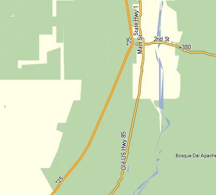
Hoping someone out there can explain this.  So i'm trying to improve my maps and make the interstates have the shield as well as the US Hwys.  Here is a sample from the mp file:
[POLYLINE]
Data0=(33.658058,-107.095794),(33.658102,-107.095731),(33.658565,-107.095055),(33.658599,-107.095006),(33.659987,-107.093034),(33.660111,-107.092855),(33.660622,-107.092119)
Label=~[0x2a]25
Type=0x01
[END]

However, as you can see in this picture from BaseCamp it doesn't seem to work:

The I-25 is shown as *25 and the US Hwy 380 is shown as +380.

Ideas?

My dictionary header has:
LBLcoding=6
Codepage=1252
#42
I agree on unintuitive; if you figure out an efficient way just let me know and I'll start downloading.
#43
The trails shown on the map are from the USGS or National Forest Service. The multiple trail problem likely means other trails exist or used to exist per those sources.  A few of the locations have trails based on people hiking it but the Chiricahua's are not one of those locations. 

If Hike Arizona would release all the trail data in one lump sum I would delete every single trail on the Arizona Topo and replace it with their data since it is likely more accurate.  However, I can find a quick way to download them all or anything like that.

If someone is willing to download all the trail files I would take them and add them in immediately.
#44
Exactly which map and do you see them in BaseCamp in the map products drop down menu at all?

I'd also suggest installing the Arizona Topo and see if that works?  If so, then try to install the WI Topo again and see if it shows correctly.

The other option is to install it to C:\Garmin\witopo11 and see if that works.
#45
Yea I debated that since I have the installer script already created. My problem is I feel that whole thing is "antiquated" since it does require you to load the maps to the C: drive which is not a great plan if you do a small(er) SSD for C: and store data in another location.