GPSFileDepot.com
 

News:

Welcome to GPSFileDepot!

Main Menu
Menu

Show posts

This section allows you to view all posts made by this member. Note that you can only see posts made in areas you currently have access to.

Show posts Menu

Messages - dbperry

#1
General Discussion / Re: Google Maps supports KMZ
July 28, 2015, 10:05:30 PM
So Google Maps DOESN'T directly support KMZ files as they had in the past. That functionality was removed earlier this year.

But I've discovered a number of solutions:

1) As mentioned above, the Gmap4 website is fantastic. Very powerful map engine. And it still supports KMZ files / overlay maps.

2) I ran into some problems that appear to be related to the speed at which the JPEG images would be read out of the KMZ files. Found a great workaround:
Within a KML file, instead of referring to embedded JPEG files within a KMZ file, simply post the JPEG images on a server and use an absolute reference to the JPEG files in the KML file. In essence, you build a KMZ file to get the proper KML language and lat-long bounds of the overlay, then you deconstruct the KMZ file and use the resulting KML file and images that were in the KMZ file.

A picture is worth a thousand words:
http://www.mappingsupport.com/p/gmap4.php?q=https://dl.dropboxusercontent.com/u/78581604/maps/blue_hills.kml

That KML file is hosted in the public section of my Dropbox. If you open / edit that KML file, you see that it refers to 24 JPEG images hosted in the Dropbox folder - not in a KMZ file.

So you get the benefits of a KMZ overlay map, with all the great features of the Gmap4 map engine, plus it renders much faster than opening a KMZ file.

The link above works great on an iPhone - and by turning "location on" in the MENU of the Gmap4 webpage, your location is displayed in real time....kind of like a GPSr....uh oh...did the Gmap4 website just put another nail in the handheld device coffin?
#2
Site Support / Re: Java Uploader
February 20, 2014, 06:37:33 AM
You may also want to uninstall all versions of Java from your machine and reinstall the latest version only. See this page:
http://www.java.com/en/download/faq/remove_olderversions.xml

See this thread for more discussion on this topic:
http://forums.gpsfiledepot.com/index.php/topic,3449.msg20041.html
#3
Site Support / Re: Big Desert map wont download
February 03, 2014, 07:30:32 AM
also, try removing older versions of Java from your machine:

http://www.java.com/en/download/faq/remove_olderversions.xml

that sometimes helps
#4
Site Support / Re: I must be stupid
January 13, 2014, 02:14:11 PM
see this thread. Sounds like exactly the same problem:

http://forums.gpsfiledepot.com/index.php/topic,2910
#5
... and just for future reference for others who might stumble onto this thread, here is a good page explaining the three most common formats:

https://www.maptools.com/tutorials/lat_lon/formats
#6
General Discussion / Re: map detail question
December 13, 2013, 05:11:24 AM
Something is odd here...the OP mentions having ONE SD card with multiple 24K maps. But then she mentions obtaining them from Garmin. My understanding is that Garmin sells 24K maps individually - so it would be impossible to obtain multiple Garmin 24K maps on a SINGLE Garmin SD card.

Kim: What region (area) are you interested in? Which particular 'custom' maps (from this website) are you trying to compare to your "24K" maps? Are the 24K maps that you already have something like this product:
https://buy.garmin.com/en-US/US/maps/on-the-trail-maps/topo/topo-us-24k-northwest/prod27609.html

I'll add my 2 cents about routable: Routable describes the functionality of being able to enter a starting point and an ending point on a GPS device and then the GPS device uses its maps to produce a sequence of roads (or sidewalks, paths, etc.) for you to follow to get from the start to the end points. Think of a 'car' GPS - "turn right on main street" - you can only get that with a routable map. As noted above, if the map is not 'routable,' then the GPS can't develop a path on the roads between the start and end points and it will just send you in a straight line.

Dave
#7
There was a NOAA map discussion a while back:

http://forums.gpsfiledepot.com/index.php/topic,2951.0.html

See especially my post...Ok, I'll repeat it here:

Quote from: dbperry on June 13, 2012, 07:08:59 AM
Quote from: Reverend Bill on June 13, 2012, 04:37:55 AM
So with my Montana, get the raster chart in TIFF, and convert it to .kmz with g-raster
That is my mission?
Thanks.
-Bill

Actually, the G-Raster program has native support for the NOAA BSB file format. So your mission is even simpler:
1) download the charts you want from NOAA in the NOAA BSB native format
2) Use G-Raster to convert them to KMZ

Reference:
http://moagu.com/?page_id=155
(See the second bullet under G-Raster features)

Disclaimer: I haven't tried this - it looks interesting - so I don't have first hand knowledge that it will work...

Dave

Using G-Raster and the BSB format from NOAA will eliminate all the problems you are having about file and tile size (as discussed by Boyd above), as well as eliminate any need to manually geo-reference the maps. I still haven't tried it, since my 78sc came with the garmin marine maps (in vector format) already loaded. So your mileage may vary. Let us know what method you finally use and how it works.

And I agree, getting vector data would be better than raster / KMZ, but at least there is a way to get raster KMZ Garmin Custom Maps - which, using G-Raster, should be relatively easy (hopefully).

Dave
#8
What do you mean "trails" map? Do you mean "My Trails" as in this map:
http://www.gpsfiledepot.com/maps/view/53/

Are you running Windows 7 64 bit? If so, did you do this:
http://forums.gpsfiledepot.com/index.php/topic,3158.msg18533.html#msg18533

Your guess at 'installer' problems leads me to think you hit the Win7 64-bit issue.

Dave
#9
GPSr Units / Re: etrex 30 / 32GB sd card issue
September 16, 2013, 08:26:43 AM
Should be 32GB for ETrex 30. But this wouldn't be the first time we have seen that Garmin is wrong about their own device's specifications. So the question is, do we have anyone who has actually used a 32GB in an Etrex 30?

this page says max 32GB for Etrex 30
https://support.garmin.com/support/searchSupport/case.faces?caseId=%7Be1f8cf10-260f-11e1-73d0-000000000000%7D

Owner's Manual doesn't specify:
http://static.garmincdn.com/pumac/eTrex_10-20-30_OM_EN.pdf

Other devices:

Oregon:
http://support.garmin.com/support/searchSupport/case.faces?caseId=%7B717f9720-6eeb-11dd-e87e-000000000000%7D


Automotive devices:
https://support.garmin.com/support/searchSupport/case.faces?caseId=%7Ba43e2650-1794-11e0-7efa-000000000000%7D

GPSMap 62/78:
http://support.garmin.com/support/searchSupport/case.faces?caseId=%7B302abc70-80e8-11e0-cbc1-000000000000%7D
#10
I'm not exactly sure if this is what is being asked here, but I'll give it a try:

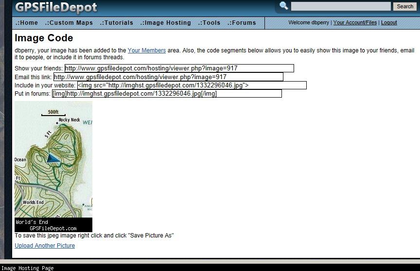
When you upload a picture to the image hosting portion of this website, you get a page that looks like this:


You need SOME of the text on the third line of code in the list of four. Copy ONLY the URL of the image - not the HTML code. For example, using my example page above, you want to copy just the "http://imghst.gpsfiledepot.com/1332296046.jpg" Then:

1) go to the page where your can edit your download page
2) position your cursor where you want the image
3) click on the little picture frame button in the middle of the second row of toolbar buttons
4) A dialog box opens...under the URL field, paste the URL of your image.
5) No need to populate anything else in that dialog box
6) Click OK and you're done!

There are other ways to do it, and if you're still not sure how to do it, I can add some better instructions.

Dave
#11
This one is web-based, but don't be scared off by that. It is really cool and if you're not afraid of learning a little KML, it is very powerful. You can print whatever you want from right in your browser, or you can get waterproof print-outs of maps - customized for what you want - through http://www.mytopo.com.

http://www.mappingsupport.com/p/gmap4.html

Info about printing is on page 80:
http://www.mappingsupport.com/p/gmap4_help.pdf

Dave
#12
No, my previous post was wrong. It appears that Basecamp will not read the <placemark> items in a KML file. That is what all those bridges, camping spots, etc. are saved as in the KML file. Looks like Basecamp only reads the data related to the track.

So perhaps conversion from KML to GPX might convert the placemarks to waypoints which will load into Basecamp.
#13
I'm just guessing on this one...

I'll bet that Basecamp just uses the information in a KMZ file related to the overlay of images. That is their documented support of KMZ files. So it is probably ignoring all of the other information in the KML file.
Edit: My thought above is wrong. Basecamp does read the track related data in the KML file inside the KMZ (even though the KML within the KMZ isn't even named doc.kml).

You could unzip the KMZ file (use any zip editor, 7-zip is good) so that you get the doc.kml file out. Then try and import that doc.kml file into Basecamp. Perhaps when you import the KML file directly, rather than as part of a KMZ, Basecamp might 'look' at all the data in the KML file, rather than just the data related to the image overlay.

You could also use a converter to convert the doc.kml into a GPX file, which might work better in Basecamp (if importing the doc.kml doesn't give you what you expect).
GPSBabel: http://www.gpsbabel.org/
GPS Visualizer: http://www.gpsvisualizer.com/convert_input
KML 2 GPX: http://kml2gpx.com/
#14
Site Support / Re: I cannot upload
July 19, 2013, 07:04:46 AM
That is odd.

See this page:
http://www.java.com/en/download/help/jcp_security.xml

The middle setting might be preventing you from running the applet, if your Java is old. But lowering it to the "Medium" setting should allow the applet to run - which you said doesn't work.

Is it possible that you disabled Java within Internet Explorer? Assuming you are using IE 9, see this page:
http://help.proctorcam.com/entries/22175352-How-to-Enable-Java-in-Internet-Explorer-9
and also see this:
http://www.chasms.com/chasms1/howdoi/disablejs/ie9jsW7.htm

My only other idea is to uninstall all versions of Java from your machine and reinstall the latest version only. See this page:
http://www.java.com/en/download/faq/remove_olderversions.xml

#15
Site Support / Re: I cannot upload
July 18, 2013, 10:31:42 PM
jbensman (and everyone):

my previous ranting reminded me to remind you to make sure you are running the latest version of Java:

http://java.com/en/download/index.jsp