GPSFileDepot.com
 

News:

Welcome to GPSFileDepot!

Main Menu
Menu

Show posts

This section allows you to view all posts made by this member. Note that you can only see posts made in areas you currently have access to.

Show posts Menu

Topics - -Oz-

#3
Map Making Support / No Interstate or US Hwy Symbols
March 19, 2016, 07:17:21 PM
Hoping someone out there can explain this.  So i'm trying to improve my maps and make the interstates have the shield as well as the US Hwys.  Here is a sample from the mp file:
[POLYLINE]
Data0=(33.658058,-107.095794),(33.658102,-107.095731),(33.658565,-107.095055),(33.658599,-107.095006),(33.659987,-107.093034),(33.660111,-107.092855),(33.660622,-107.092119)
Label=~[0x2a]25
Type=0x01
[END]

However, as you can see in this picture from BaseCamp it doesn't seem to work:

The I-25 is shown as *25 and the US Hwy 380 is shown as +380.

Ideas?

My dictionary header has:
LBLcoding=6
Codepage=1252
#4
Site Support / GPSFileDepot Has Gone Secure
February 06, 2016, 09:50:19 AM
GPSFileDepot has gone secure (https). If you notice any issues please let me know.
#5
All,

I have completely rewritten the How To Create Garmin Topo Maps tutorial. This was a major rewrite and was done as I updated the Arizona Topo map.

Biggest changes:

  • Added support/info for QGIS (it's free and can definitely be used in place of Global Mapper); seemed popular on the forums here so I thought I'd try it out
  • Huge updates with data availability because they've added a lot more to the USGS National Map (especially in contours and water data, much faster)
  • Improved all the "automated" files; for all of them its as simple as set the folder name in the file and then double click and it'll automatically do a lot of the work
  • Included "clipping" as part of the tutorial; now the maps you make will end at the state border; much cleaner
  • Created new software to convert shapefiles to mp files.
  • Removed most of the GPSMapEdit information - with QGIS and Global Mapper there is really no reason to use the non-automated processes that GPSMapEdit required
  • Lots of updates for ease of execution/understanding
Anyway, I post this here for two reasons:
1. If you see any issues/errors please let me know
2. If you are using some of the processes from the previous tutorials (bat files especially) have huge updates that will speed up what you do.
#6
Map Making Support / USGS 1:24k Contours
January 05, 2016, 06:50:45 PM
So I am finally updating some of my maps and what browsing the National Map Viewer (have to update the tutorials too) I noticed they now have straight up 1:24k contours. They're at 1/3 arc sec which means that they "redo" the contour interval at those borders. This creates a few weird areas but it means that for my Arizona Topo instead of having a straight 30 or 40 ft contour interval in the flatter areas it'll be 5ft or 10ft.

Has anyone started using these contours instead of actually building from the DEM files? Seems like it would save a lot of computing time.  Also, the new downloader seems like it'd be nice but so far it isn't working...
#7
Site Support / New File Uploader
February 20, 2014, 07:07:34 PM
The java uploader for map files has been replaced with a more modern method.  This replacement was required to due security issues with Java that ended up with them restricting applications from running based on certificate type (issue here).

The new upload method works best from a modern browser (new version of Chrome or Firefox as well as more recent versions of internet explorer) but will fall back to using flash as required.

There are a few "oddities" that may be experienced when selecting files but they have been addressed in the help box to the right of the upload area.

If you encounter any issues please post them here.
#8
Site Support / Session Timeout Errors
March 14, 2012, 05:46:53 PM
If you run into any more session timeout errors please (try) reply to this thread.  I believe it has been fixed.

Note that you will likely have to log in again.
#9
Site Support / Security Improvements
March 05, 2012, 09:12:30 PM
There have been many security upgrades in the last couple days.  If you see any weird anomalies with anything (especially uploading).  Let me know in this thread.
#10
Question originally posted by Wyo
Currently, I run maps in conjunction with a Garmin 20x usb GPS receiver on a laptop.

I have the Wyoming Maps that I use on my handheld GPS as well as downloaded on a laptop to use in conjuction with BaseCamp.

Is there any capability for BaseCamp to work with a Garmin 20x receiver to, in essence, use the Hunting Maps software via BaseCamp as a laptop GPS?
#12
Site Support / GPSFileDepot: New Design/upgrades
September 18, 2011, 12:24:05 PM
All,

As you can see the new version of GPSFileDepot has gone live.  Although I attempted to do extensive bug testing there are likely a few issues floating around.  This is the thread to post any problems you run into.  The new design also moves the code and features into modern times and includes some upgrades to help users get help and get content with ease.

When posting a "look" problem please include what browser and version you are using.
#13
Map Making Support / TBD issue?
March 06, 2010, 01:18:20 PM
Okay, so compiled a new arizona map and although it appears to have gone well each time I create the .tbd, .mdx, and .img files for the preview it crashes in mapsource.

it is only occuring with the new Arizona img files because i recompiled the preview stuff for another of my maps and it worked just fine.

here is the error Mapsource spits out:
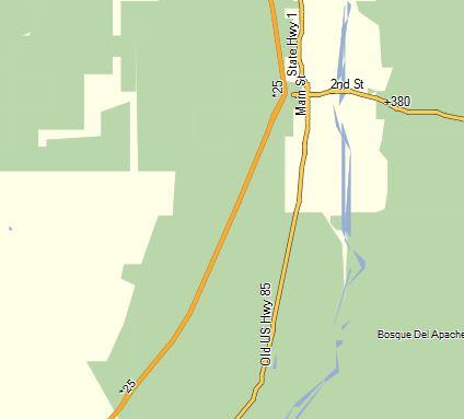
Quote<?xml version="1.0" encoding="UTF-8" standalone="no" ?>
<ErrorReport xmlns="http://www.garmin.com/xmlschemas/ApplicationErrors/v1">

  <Error>
    <Exception>
      <SourceCodeLocation>
        <SourceFileName>TDB_REGIONDIR.CPP</SourceFileName>
        <SourceFileLine>164</SourceFileLine>
      </SourceCodeLocation>
      <Extra>
Product ID: 213778433
Region ID: 0</Extra>
    </Exception>
    <Application>
      <Name>MapSource</Name>
      <Build>
        <Version>
          <VersionMajor>6</VersionMajor>
          <VersionMinor>15</VersionMinor>
          <BuildMajor>11</BuildMajor>
          <BuildMinor>0</BuildMinor>
        </Version>
        <Type>Release</Type>
        <Time>Jan 26 2010, 11:31:06</Time>
        <Builder>sqa</Builder>
      </Build>
      <LanguageID>1033</LanguageID>
      <PartNumber>006-A0041-00</PartNumber>
    </Application>
    <Computer>
      <OperatingSystem>WIN32 Windows Platform, Major Version: 6, Minor Version: 1 </OperatingSystem>
      <Processor>x86, Processor Level: 6, Processors:2, Model: 15 Stepping: 13</Processor>
      <RamSize>2086928</RamSize>
    </Computer>
    <Time>2010-03-06T21:15:52Z</Time>
  </Error>

</ErrorReport>

Ever seen it before?

The .img files were compiled with cgpsmapper shareware 0100a on windows 7 64bit
#14
Site Support / Editor's Choice Maps
February 07, 2010, 10:39:47 PM
Since there are quite a few maps now to make it easier on our new users I believe that GPSFileDepot needs to have an Editor's Choice category.

Obviously category searching is not publicly integrated yet but testing is ongoing.

To that end I need help picking maps that should be labeled "Editor's Choice".

I am open to suggestions but am setting these requirements right now

  • Must have an installer (unless its a "custom map")
  • Should be the best map of its type for a standard category (for example the Florida topo is the best topo maps of all the Florida topos because it covers the whole state and meets most user's immediate requirement
  • Should be up-to-date (for example the planimetric maps will be editor's choice while IbycusUSA won't be because its now out of date)
  • Needs to be free (unless its amazing)
  • Shouldn't be targeted to a specific audience (the land ownership maps are great and hunters love them, but the main users are hunters)

I am open to suggested maps and/or suggested requirements/changes to those listed above.

The following maps are currently selected to be Editor's Choice based on popularity or function:
- Arizona Topo http://www.gpsfiledepot.com/maps/view/1/ (new version processing now, still probably 2wks out)
- World Shaded Relief http://www.gpsfiledepot.com/maps/view/277/
- Florida Topo http://www.gpsfiledepot.com/maps/view/123/
- South East United States http://www.gpsfiledepot.com/maps/view/101
- All The Planimetric Road Maps

The following are maybes:
- California topo (I'd love one without the two layers) http://www.gpsfiledepot.com/maps/view/28/
#15
We have a tutorial that will show you how to load maps on your Garmin GPS with either a PC or a Mac; click here to see the tutorial.

If the map you're downloading doesn't have an easy installer you can use this tutorial to load the maps into MapSource/Basecamp.  Note: you cannot use this tutorial for the OSM routable maps.
#17
Map Making Support / Tiger Data vs OSM
January 20, 2010, 10:58:04 AM
All,

Looking for opinions since I'm starting the update process for my maps.

Which data is better (in general) the latest Tiger data or the open street maps data.

I'm starting with Arizona and then moving to my other maps so which road data should I include?
#18
Site Support / Site Updates
January 13, 2010, 12:15:33 PM
So, now that I'm home I've been working on some small and "larger" updates.

Completed Updates:
- Added Garmin Custom Maps as a checkbox option for the maps; if this box is checked then it will mark the maps as mac and windows compatible and change the download link
- Added editor's choice option (only admins can set them at this point)
- Enabled some more countries for map additions
- Change how maps are displayed on the maps listing page (15 Feb 10)
- Create a search function to allow you to filter maps by features (15 Feb 10)
- Update my topo maps (Arizona complete 10 Mar)
- Update how to load maps to GPS tutorial

To do:
- Update my topo maps (Hawaii next due to roads issue)
- Tutorial on how to upload maps
- Create a generic FAQ
- Add some more pop/options to the front page
- "Force" people to check out the tutorials after they download

I am open to suggestions...
#19
Site Support / Site Updates: Maps View Updates
June 11, 2009, 09:41:06 PM
Hey All,

I've updated some of the pages on this site and wanted opinions on any possible improvements.

The largest update (which will soon grow into more) is this conversion on the viewing maps page:


To make the update more accurate I need people to modify their maps (i'm getting the ones I can) and check the appropriate map features boxes.  Try to click "Minor Modification" at the bottom so that it doesn't change the date you loaded the map.  I've tried to hit some of the most popular maps right now.

I've also added authors to the articles and creators to the map based on member name.

For the near future:
- Search by map features
- Sort maps page by newest; features; etc.
- View maps uploaded by user
- Select multiple countries when adding maps - Done 15 Jun 09

If there are any other improvements programming wise that you would like or have ideas for improvements (including map features to help narrow it down) do let me know in this thread.
#20
Site Support / Gone Until May 5th
April 22, 2009, 10:52:30 PM
I will be in Japan for about 10 days.  I won't have internet for a lot of it.  I'll be back online May 4th or 5th Alaska time.

Any major issues will have to wait until I get back.